|
Introduction
The Tamalin site is located in Ailan Li of Puli Town in Nantou County on the east side of the Ailan Plateau and roughly includes the area where the Puli Christian Hospital, Affiliated Senior High School of National Chi-Nan University (originally National Puli Senior High School) and the Xingling Temple are located. This is one of the earliest discovered prehistoric sites in Taiwan and many excavations have been conducted at this site (see figure). According to the results of past surveys, it is likely that the entire Puli Christian Hospital is within the geographic distribution of the Tamalin site.
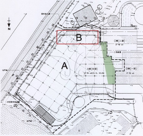
The fourth phase (Building A) of the new medical treatment wing is located in the northeast corner of Puli Christian Hospital. The first phase of the project involved tearing down the old medical treatment building and digging a foundation. Puli cultural worker and historian Shi-Lang Jian reported his observations of apparent damage to the Tamalin site to the proper authorities. The Ministry of Education assigned the National Museum of Natural Science the task of carrying out a comprehensive archaeological excavation of the fourth phase of construction (Building A) in sector B (highlighted in red) to salvage this prehistoric site and to record architectural remains and burials. Excavation was carried out over 45 working days from May 12 to July 12, 2003 in a systematic grid pattern. From west to east, there were 12 columns, denoted A, B, C, D, E, F, G, H, I, J, K and L, respectively. From south to north, there were 8 rows, denoted 1, 2, 3, 4, 5, 6, 7 and 8, respectively. A total of 79 2m x 2m excavation units were marked off over an area of 280m2.
Tamalin II site (Puli Christian Hospital) excavation area
Diagram of the locations of previous excavations of the Tamalin site
Tamalin II site pit locations
Tamalin II site pit distribution diagram
Environment
The Puli Basins are located in Nantou County. This is a sunken area of adhesive slate from the Central Mountain Range, located along the upper reaches of the Dadu Stream between the Beigang and Zhuoshui streams. Along a distance of about 30 kilometers there are more than a dozen mountain basins arranged along an orientation from north-northeast to south-southwest. Among the Puli Basins, the northernmost Puli Basin is the largest, measuring approximately 10 kilometers in length (south to north) and 6 kilometers in width. It is surrounded on all sides by mountains.
The Ailan (Wuniulan) Plateau is located just west of the center of the Puli Basin. This basin was formed by the Nangang and Mei streams which cut through this area. This plateau is broadest in the east, narrowing in the west. On the southern side the plateau faces cliffs formed by the Nangang Stream. Between the north side and lowest point in the basin, the topography is gentle sloping.
The Tamalin site is located on the east side of the Ailan Plateau in Ailan Li of Puli Town, Nantou County. Its center is located at N23°58’21”, E120°56’16”or grid coordinates N2652000m×E243600m (TW67). Elevation ranges from 427 to 436 meters. Distribution area of remains measures about 500 meters from south to north and about 350 meters from east to west.
View of the excavation site looking east from the roof of the Puli Christian Hospital
View of the site during excavation work
View of the Puli Basin from the roof of the Puli Christian Hospital
Excavation site conditions
The archaeological team employed comprehensive excavation methods. Clear and distinct boundary walls were left on the west, south and east sides. On the north side, the cultural layers were almost all damaged. In addition, for convenient removal of dirt, digging was carried out to the edge of the pit. Thus, no boundary wall was left. Although the excavation area had been disturbed and damaged numerous times, there was complete preservation of cultural layers in many places. A large number of prehistoric objects were found, as well as stone walls, trash pits and burials. In comparison with several excavations that had taken place at the Tamalin site in recent years, there was better preservation of excavated layers during the 2003 excavation.
Tamalin II site archaeological excavation team
Workers erect a canopy to protect the excavated pits
Excavation work begins
Researchers formulate a direction for excavation work
Carrying out excavation work
Workers uncover an area of fire-scorched surface F2
Photographic record of excavation work
Illustration of the excavation of a pit
Boundary wall on the west side
The international digital archives and e-learning communication project of the National Museum of Natural Science
National Museum of Natural Science
|
 A Slice of Wonder