|
Introduction
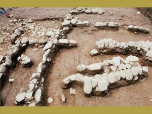
The east section includes pits on the east side that were disturbed during the removal of some trees. The scope includes 25 pits: F1-F5, G1-G5, H1-H5, I1-I5, and J1-J5. The unearthed architectural remains are relatively complicated and mainly include fire-scorched surface F2, erect slate structures F12 and F13, and stone structures F14, F15, F16, F17, F18, F19, F20, F21, F23 and F26, as well as flat slate structure F32, etc.
Fire-scorched surface F2
Fire-scorched surface F2 is an area of hard soil that shows evidence of having been scorched by fire. The color is a mixture of reddish brown and charcoal gray. However, no charcoal was discovered. This feature is mainly distributed in pits G4, H3, H4, I3, I4 and J3, extending east into the east wall of pit J3. This feature was not completely excavated. The section that was surveyed measured 8.2 m in length and varied in width from approximately 1-2 m. Average thickness was approximately 6 cm. The major axis was oriented west by north 17°, similar to the orientations of architectural structures and burials. Although the surface was nearly flat, there were slight inclines from north to south and from west to east. This feature was highest along the south side at the east end at approximately 110 cm below the surface. The north end was at approximately 125 cm below the surface. The west end of this feature was at about 130 cm below the surface.
Stone structures F21, F15 and F14 were constructed on top of fire-scorched surface F2. Thus, fire-scored surface F2 is from an earlier time period than these features.
Three current hypotheses regarding the nature of fire-scorched surface F2 are listed below:
1. The prehistoric residents at this site purposefully used fire to clear this area for some type of daily life activity.
2. This area was scorched due to a house fire.
3. This area was where the prehistoric residents of this site fired pottery.
Although there is not enough evidence to precisely determine the cause of fire-scorched surface F2, from the orientation and location of this feature, it appears that it was related to architectural structures. Thus, the first hypothesis regarding the clearing of an area for daily life activity appears to be the most likely followed by the house fire hypothesis. Due to the long, strip-like shape of fire-scorched surface F2, it is unlikely that pottery was fired here.
Stone structures F15-17, 21
Stone structures F21 and F15
Stone structure F21 crosses pits H1, H2 and H3 and extends southward into the south wall of pit H1. This feature was not completely excavated. The section that was surveyed measured approximately 6 m in length. This feature was formed from a single row of rocks of varying sizes and is slightly higher along the south end than the north end. It was found at 70-100 cm below the surface with an orientation north by east 10°. This feature is located in the southeast corner of the excavation area in the cultural layer 60-70 cm or more below the surface. It was damaged during construction. Thus, stone structure F21 should have more than one layer but the upper layers have been destroyed.
Stone structure F15 is located in pits I3 and J3 and perhaps extends eastward to the east wall of pit J3. The section that was surveyed measures approximately 4 m in length. This feature is a single-layer, single-row structure formed from rocks of varying sizes. It is located at 80-105 cm below the surface along a west by north orientation of 14o.
As the north end of stone structure F21 and the west end of stone structure F15 connect at nearly right angles and are situated at approximately the same depth below the surface, it is possible that these features were part of the same architectural structure. Although stone structure F21 and stone structure F18 are connected at nearly right angles, stone structure F21 was constructed above stone structure F18. Thus, stone structure F18 is from an earlier time period than stone structure F21.
Stone structure F16
Stone structure F16 is located in pits I2 and J2, extending eastward to the east wall of pit J2. This feature was not completely excavated. The section that was surveyed measured approximately 2.8 m in length and was formed from rocks of varying sizes in single or double layers. This feature is located at 65-100 cm below the surface along a north by east orientation of 15°.
As there is a separation of only 1 m between the west end of stone structure F16 and the east end of stone structure F18 and they connect along the same orientation with their bottom edges at approximately the same depth below the surface, it is possible that these were originally parts of related architectural structures.
Stone structure F17
Stone structure F17 is located in pits I1 and J1 with a length of approximately 2.6 m. This feature was formed from rocks of varying sizes arranged in 3 to 4 layers. Larger rocks were placed at the bottom with smaller rocks on top. However, along the south section, the entire structure has toppled over. This feature is located at 50-100 cm below the surface and was taller before the toppling occurred. Orientation is west by north 10°. This is inconsistent with the orientations of most of the architectural features of the Tamalin site.
Stone structures F12, 14, 32
Mixed erect slate and stone structure F12
Feature F12 is a mixed erect slate and stone structure mainly located in pits I5 and J5. The section that was surveyed measures approximately 4 m in length. This feature is made up of two pieces of erect slate and a continuous arrangement of rocks. At the east end of feature F12 are several scattered rocks. It is possible that these were part of the stone structure extending into the east wall of J5. On the west end is an erect slate piece (99 cm x 25 cm x 2 cm) with an orientation west by north 16°. This feature is situated at a depth of 130-155 cm below the surface. Following the orientation of the slate, the west end connects to a stone structure measuring approximately 1.3 m and made up of piles of crushed stone. Much of the crushed stone toppled over onto both sides. The west end of this stone structure is connected to another erect slate piece (98 cm x 20 cm x 2 cm). The same orientation is maintained. However, it is shifted about 40 cm on the north side. This section is situated at a depth of 145-165 cm below the surface, or about 15 cm farther from the surface than the slate piece to the east.
Flat slate structure F32 and feature F12 are in close proximity to one another and at similar depths below the surface. It is possible that they are architectural remains from the same time period.
Flat slate structure F32
Flat slat structure F32 is located in pits I4 and I5. This feature is comprised of 5 flat pieces of slate and measures approximately 1.65 cm in length. It is situated at a depth of 140 cm below the surface. The major axis is oriented north-south. The north end of feature F32 is in close proximity to the south side of mixed erect slate and stone structure F12 and is at a similar depth below the surface. It is possible that these are architectural remains from an earlier time period.
Stone structure F14
Stone structure F14 is a single row of rocks oriented north by east 10°. Along its north end it is situated on top of flat slate structure F32. At the south end it turns at a right angle with orientation east by south 10°. This appears to be a corner where two walls meet. However, the damage is relatively severe. This feature is situated at a depth of 90-120 cm below the surface. From the layout diagram, stone structure F14 may be related to stone structures F15 and F21.
Stone structures F18-20, 23
Stone structures F20 and F18
Stone structure F20 is located in pits G1 and G2 and extends southward to the south wall of pit G1. This feature was not completely excavated. The section that was surveyed measures approximately 3.5 m in length. This feature is comprised of varying sizes of rocks. It is slightly higher in the south than in the north and is at a depth of 90-120 cm below the surface with an orientation north by east 15°.
Stone structure F18 is located in pit H2. The section that was surveyed measures approximately 2.5 m in length. This feature is comprised of rocks of varying sizes arranged in a single row and a single layer. It is situated at a depth of 85-110 cm below the surface with an orientation west by north 10°.
The north end of stone structure F20 and the west end of stone structure F18 intersect at nearly right angles and are at similar depths below the surface. It is possible that these were part of the same architectural structure and were most likely from an earlier time period than stone structure F21.
Stone structure F23
Stone structure F23 is in a single layer, single row arrangement. It is located in pit G3 at a depth of 100-130 cm below the surface. This feature is incomplete. It appears slightly arc-shaped without clear orientation. Perhaps these are the remains of an architectural structure.
Stone structure F19
Stone structure F19 is in a single layer, single row arrangement. It is located in pits F2 and G2 with a length of approximately 2.2 m. This feature is situated at a depth of 110-130 cm below the surface with an orientation west by north 13°. It lies adjacent to the south side of slate coffin burial M4. The west end of stone structure F19 was damaged during the uprooting of trees. Thus, it is not possible to view this feature in its entirety. It is also not possible to confirm if stone structure F19 is associated with slate coffin burial M4 or whether this was the foundation of a wall.
F13,26 Stone structures F13, F26
Erect slate structure F13
Erect slate structure F13 is mainly located in pits F5, G5 and G4. The west end was destroyed during the uprooting of trees. The remaining length is approximately 3.6 m. This feature is comprised of 8 pieces of slate in varying sizes standing erect in a continuous arrangement. The east end is at a depth of 110-150 cm below the surface. The west end is at a depth of 130-160 cm below the surface. The orientation is west by north 14°.
Following the orientation of erect slate structure F13 along a line extending eastward it precisely lines up with an isolated piece of slate (72 cm x 26 cm x 2 m) standing erect in pit I4 at a distance of about 3 m from the east end of F13. Along the same orientation, the depth is 115-140 cm below the surface. It is very possible that this isolated piece of slate and erect slate structure F13 are from the same set of architectural structures.
Stone structure F26
Stone structure F26 is a single layer, single row arrangement of rocks located in pit F5. The remaining length is approximately 1.2 m. This feature is situated at a depth of 140-160 cm below the surface along an orientation north by east 15°. As this structure intersects with erect slate structure F13 at nearly right angles and both of these features are at nearly the same depth below the surface, it is possible that they are architectural remains from the same time period. However, due to extensive damage, it is not possible to confirm this relationship.
Summary
The damage to the east section is more extensive than that to the west section. The upper section of the cultural layer has been damaged with comparatively poor preservation of cultural features. According to the excavation data regarding the features, an attempt was made to conjecture about their nature and time relationships:
1. The lower edges of erect slate structure F13 and mixed erect slate and stone structure F12 are at a depth of about 150-160 cm below the surface. These represent the architectural remains farthest from the surface in the east section. From comparisons of the earliest architectural remains from the west section, erect slate structure F7, the materials and form are similar, as are the depths below the surface and orientations. Thus, it is possible that these are architectural remains from an earlier period of the Tamalin site.
2. Flat slate structure F32 is situated at a depth of about 140 cm below the surface, which is similar to the depth of mixed erect slate and stone structure F12. It is possible that these are architectural remains from the same time period.
3. Erect slate structure F13 and the isolated slate piece in pit I4 are adjacent to the north edge of the fire-scorched surface F2 and at a similar depth (130 cm below the surface). It is possible that these architectural remains are from the same time period and are related.
4. Stone structures F20, F18 and F16 are possibly from the same architectural structure denoted dwelling 3. The interior surface of the dwelling is at a depth of about 110 cm below the surface. Stone structures F21 and F15 are from a later time period and constructed on top of dwelling 3. They are denoted dwelling 4. The interior surface of this dwelling is slightly higher than that of dwelling 3, at about 100 cm below the surface.
5. Stone structure F14 is from a later time period than flat slate structure F32. From the location and depth below the surface, it is possible that this is from the same time period and is related to dwelling 4.
6. The lid of slate coffin M4 was found at a depth of 130 cm below the surface and is possibly from an earlier time period than dwelling 3 and dwelling 4. However, it is possible that only stone structure F19 remains from among the architectural structures associated with M4.
7. The orifices of trash pits F28 and F29 are at a depth of 120 cm below the surface and on top of dwellings 3 and 4.
8. The base of slate coffin M1 is situated at a depth of 70 cm below the surface. It can be conjectured that the lid was at about 50 cm below the surface. The cultural layers above 60 cm were damaged. Thus, all of the architectural remains from the same period as slate coffin M1 may have been destroyed. Slate coffin M1 is most likely the latest cultural feature remaining in the east section, and is from a much later period than dwelling 4.
The international digital archives and e-learning communication project of the National Museum of Natural Science
National Museum of Natural Science
|


 A Slice of Wonder


