|
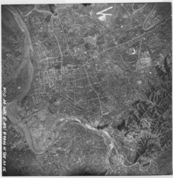
Aerial photo of the Taipei basin taken by American forces |
|
Tags: documents | maps
|
| |
Date: 1947/09/15
Illustration: Aerial photo of the Taipei basin taken by American forces
Original archiving department: Energy and Environment Research Laboratories, Industrial Technology Research Institute |
| |
| Description: This aerial photo shows the natural sights of the Taipei basin 60 years ago, revealing the undeveloped area of eastern Taipei. This photo demonstrates the post-war urban geographical landscape of Taipei. |
| |
| Text and images are provided by The Map and Remote Sensing Imagery Digital Archive Project, Academia Sinica |
|
 A Slice of Wonder


