|
Tags: FORMOSAT-2 | geography
On May 21,2004,the FORMOSAT-2 satellite successfully lifted off to begin Operations in space as Taiwan's space industry launched into a new era. Flying in a sun-synchronous orbit at 891 km above sea level, this satellite circles the globe about 14 times each day. FORMOSAT-2 has a unique daily revisit design and autonomous operation capabilities. This enables Taiwan to take its own remote sensing images of the Earth and to provide data to the international community for various applications such as land planning , disaster prevention and relief, ecological conservation, and environmental research. Moreover, in scientific research, FOR-MOSAT-2 has successfully captured the first photographs of red sprites, blue jets, and other upper atmostpheric transient luminous phenomena, helping scientists to better understand the effects of space weather on Earth's climate.
The island of Taiwan is located on the convergent boundary between the Eurasian and Philippine Sea tectonic plates. Surrounded by water, the island only stretches over 300 km from north to south but has more than 1,100 km of coastline. Active crustal movement in the region has created magnificent landscapes, forceful monsoons, turbulent waves, and copious rainfall, all of which have carved special features into the north, east, south, and west coasts. Also, the complex currents and seabed terrain of the island's surrounding waters have formed a rich and unique marine ecology.
FORMOSAT-2 passes above Taiwan and watches over this beautiful Island every day. Through the eyes of this satellite, you can view down on charming images of Taiwan lying serenely in a crystal blue ocean. Closer to the shores, you'll be surprised at the beauty and craftsmanship found in the landscape, as well as the teeming ecology of surrounding waters. Whether you consider this land to be your native soil or an unfamiliar country, these 891-km high views combined with breathtaking seaside pictures will bring you a different perspective on the beauty and diversity of Taiwan.
 Photo by: National Space Organization
 |
Dongsha Atoll
An atoll is a circular reef that grows continually upward due to rising seawater levels and eventually forms a circular island. Dongsha Island and its surrounding coral reef are a classic example of an atoll.
|
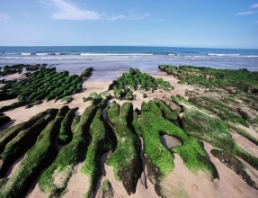 Photo by: Ching Chun Tu
 |
Stone Troughs of Laomei
In Laomei Bay in the northern coast of Taiwan, the rocks are made of volcanic rock and provide an ideal environment for algae to thrive in. As ocean waters abrade over the rising reef, the softer materials are eroded away, leaving behind curvy stone troughs on the seashore.
|
 Photo by: Min-Ming Chen
 |
Keelung Islet
Keelung Islet is the most significant landmark island in north-ern Taiwan. Composed mainly of quartz-andesite, this vol-canic island is surrounded by cliffs on all sides, and more than 90% of its terrain is inclined at a slope of more than 60 degrees.
|
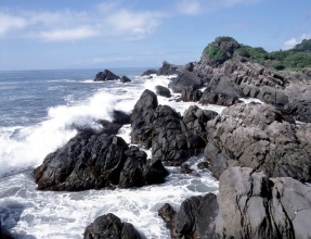 Photo by: Min-Ming Chen
 |
Peikuan Cuesta Formations
The rock layers at Peikuan are mainly composed of sandy shale, and were created over 30 million years ago as a part of the Tatungshan Formation. After being forced to tilt upward by the crust stress, the shale was eroded away over time and resulted in the col-lapse of overhanging sandstone layers. This created the largest and steepest cuesta on the northeast coast.
|
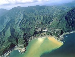 Photo by: Min-Ming Chen
 |
Yin-Yang Sea
Due to the influence of natural weathering, the iron ores in the mountain of Jinguashi gradually dissolve into large amounts of ferrous ions(Fe ) that flow with rain and underground water into Shuinantung Bay. The ferrous ions undergo oxidation and become iron hydroxide colloidal suspended particles appearing yellowish-brown during this process. With limited dispersion in the seawater, this process has resulted in the seawater forming a blue-and-yellow phenomenon called the Yin-Yang Sea.
|
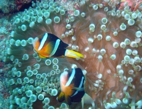 Photo by: Kwang-Tsao Shao
 |
Clark's Anemonefish
Of the world's 28 different species of anemonefish, five can be found right in the waters of Taiwan. The Clark's anemonefish in particular are a gregarious fish, and each school usually contains only one female. If the female dies, the largest male will morph into a female to take its place. Taiwan already has the capability to breed these fish artificially.
|
 Photo by: Min-Ming Chen
 |
Suao-Hualien Coast:Cingshuei Cliff
The Suao-Hualien Coast lies where the north end of the Central Mountain Range meets the Pacific Ocean. The land stretching from the coastline up to nearby divides is inclined more than 45 degrees on average, and the coastal rocky cliffs drop almost vertically due to severe wave erosion. Along this coastline, the Cingshuei Cliff offers the most spectacular scene with a relief of over 1,000 meters, making the cliff a popular sightseeing spot.
|
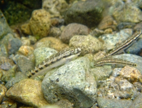 Photo by: Ching-Yi Chen
 |
Goby
The goby is a small fish that originated in the ocean and now lives in freshwater streams. Each spring as the Kuroshio Current flows northerly up eastern Taiwan, it disperses some of these gob-ies along the rivers and islands off eastern Taiwan. As many as 19 different goby species are found in this area.
|
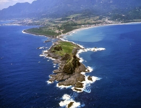 Photo by: Min-Ming Chen
 |
Sansiantai Island in Taitung
Sansiantai Island is made of volcanic agglomerate and covers an area of only 22 hectares. This spot was originally a cape, but continuous wave erosion eventually cut through the neck of the cape and created an offshore island. The entire island is marked by erosion features, such as sea grooves, potholes, stacks, and notched walls. Off the shoreline, coral reef rocks encircle the whole island.
|
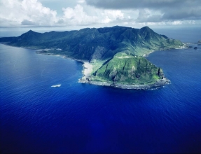 Photo by: Min-Ming Chen
 |
Lanyu Island
The small island of Lanyu was formed during volcanic erup-tions some 4 to 6 million years ago. Surrounded by coral reef, this island lies far away from the continent and has been isolated geographically for a long time. As a result, the life forms and cul-ture in Lanyu have specialized to adapt to their environmental set-ting and are unique among the earth's ecologies.
|
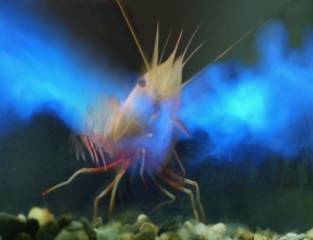 Photo by: Tin-Yam Chan
 |
Mino Nylon Shirmp
The mino nylon shrimp(Heterocarpus sibogae) is a marine benthic dweller that lives at depths of 200 to 500 meters and can produce luminous clouds. When threatened, it will emit two streams of blue luminous secretion from its mouth to confuse the predator's vision. Locally it is also called the “mother shrimp” because it broods a large number of eggs that are bright blue in color. This species of shrimp is found in the deep waters off eastern and southern Taiwan.
|
 Photo by: National Space Organization
 |
Suao Harbor
|
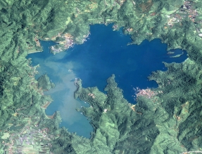 Photo by: National Space Organization
 |
Sun Moon Lake
|
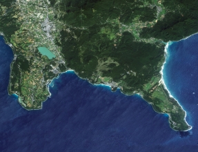 Photo by: National Space Organization
 |
Kenting National Park
|
 Photo by: National Space Organization
 |
Taiwan High Speed Rail Taichung-Wuri Station
|
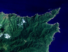 Photo by: National Space Organization
 |
Bitou Cape
|
The copyrights of the texts belong to National Science Council, Taiwan
|


