


TELDAP Collections
 A Slice of Wonder
Facets of Taiwan
Exhibitions
| Mapping the Imperial Realm - an Exhibition of Historical Maps |
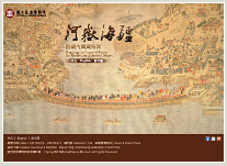 Despite practical purposes, maps in the process of development were also full of rich cultural elements. The makers of Chinese ancient maps emphasized brushwork, composition, and atmosphere, rendering their maps more in the sense of paintings. As Cordell D.K. Yee points out in his History of Chinese Cartography, poetry, calligraphy, and painting, all three are indispensable to the making of an ancient Chinese map. Through the fusion of image and text, maps inform as well as represent. They are not only pragmatic guides to use but also beautiful works of art to look at. Despite practical purposes, maps in the process of development were also full of rich cultural elements. The makers of Chinese ancient maps emphasized brushwork, composition, and atmosphere, rendering their maps more in the sense of paintings. As Cordell D.K. Yee points out in his History of Chinese Cartography, poetry, calligraphy, and painting, all three are indispensable to the making of an ancient Chinese map. Through the fusion of image and text, maps inform as well as represent. They are not only pragmatic guides to use but also beautiful works of art to look at.
The present exhibition features a selection of ancient maps from the cartography collection of National Palace Museum in Taipei (http://www.npm.gov.tw/exh101/historical_maps/en/en1.html). These river, mountain, sea, and territorial border maps made during the Ming and Qing dynasties are presented in three themes: “Charting the Rivers,” “Guarding the Seas,” and “Marking the Borders,” showing both the traditional mapmaking techniques and particular concerns of the times. The exhibition will close on March 31, 2013.
|
You are the 


 visits (since January 2011)
visits (since January 2011)